TALES FROM THE TRAIL (AND SOMETIMES THE ROAD TOO)

Showing posts with label Silverado Motorway. Show all posts

Wednesday, January 8, 2014

The Longest Three and 1/2 Miles Ever!

With Winter Break over, the utter chaos gone, I wanted to get away for some trails today.  I didn’t care how many miles I “ran”.  I wanted quality.  And so, I drove two hours (round trip, an hour there and back), yes two hours to run up a little trail called Silverado Motorway (AKA Silverado Trail, Bedford).  (We by the way measure driving distance in minutes and hours here in Southern California – I know, pretty crazy). 

You may think it’s a tad bit crazier to drive two hours for a 3.5 mile trail.  Just wait.  I had the mountain completely to myself.  Seriously.  It was just me and the hawks.  On the other hand, the out trip was flipping hard.  A mile in, I was ready to give up.  But I couldn’t make that drive and turn back after only one mile.  I struggled onward, delighting in the cold breeze. The road was steep, rocky and with an edge I could easily fall off with a little trip on a stone.  Soon the gloves were off and after an hour and a half I finished the longest three and a half miles ever!  The trip back down was much, much quicker. Winking smile

Silverado Motorway out-and-back:Running Silverado Motorway out-and-back 1-8-2014, Elevation

Beginning that treacherous switch-back climb:

The mountain wall – looks like someone built it:

Still going up:

Heading back:

Running Silverado Motorway out-and-back 1-8-2014

Sunday, November 10, 2013

Searching for Bedford

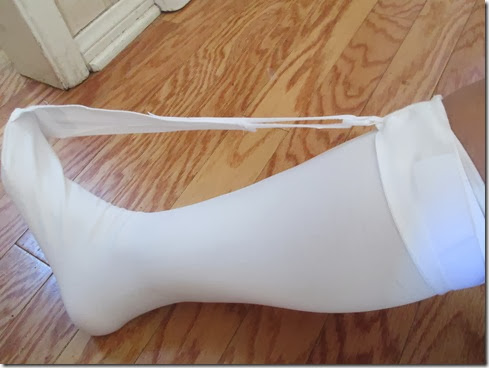
I got The Sock (The Strasser Sock) and slept in it last night.  I woke able to walk, and with little pain.   I slept in a little and got a later than usual start for a mountain run.  That was a-okay.  I’m ready to roll with the punches.  I merely decided on a shorter route to The Main Divide for my search of Bedford Peak in the Santa Ana Mountains. 

My shorter route was straight up, and I mean STRAIGHT UP the Silverado Motorway (AKA Silverado Trail).  It’s a bear of a climb, though most of it is runnable (a very slow run for me!).  The gain is 1,800 feet over 3.25 miles.  I didn’t stress over it though – still rolling with the punches Winking smile.  Besides, the views made the trip well worth it.  And best of all, the weather was cool, almost on the cold side.  (One mountain biker in the trailhead parking lot was wearing a jacket, shivering and told me it was “freezing.”  Giggle.  It was perfect running weather for me.)

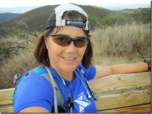
Running up the Silverado Motorway:

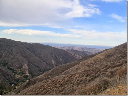
Well, I studied maps, looked at satellite photos, read articles in order to narrow my search for Bedford Peak.  It seemed to me, that the peak was near the start of the first giant “U” The Main Divide made.  The first peak looked too small, I passed it up.  The second, much larger peak looked promising.  I made my way up the steep single track and ran along the top looking for a surveyor’s marker.  The trail was overgrown and seemed seldom travelled and I thought I probably had not found Bedford Peak.  I ran to the edge anyway, and lo and behold, found a bench.  A bench!  Next to the bench were granola bars and jugs filled with water.  I thought for sure I had found Bedford Peak. 

Views from this peak:

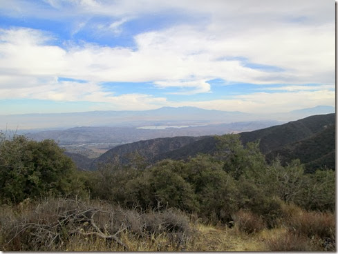
I searched the entire peak for a surveyor’s marker.  Nothing.  I double checked the rocks, looked carefully for pieces of slab.  This peak was completely void of any markers.  Usually, they are pretty easy to find, so I figured I had not found Bedford Peak.  Slightly bummed, I ran down the peak and at the bottom came upon a ranger whom I know as “Hollywood.”  He asked if I was okay.  I said I was,  then asked, “Where the heck is Bedford Peak?”  He thought it was 3 or 4 peaks away.

So, I took off along The Main Divide, climbing every peak, large or small.  Then I came upon another ranger.  He asked if I was okay.  I said I was, then asked, “Where the heck is Bedford Peak?”   He studied his map some.  I sensed he wasn’t quite sure when he pointed off in the distance and said, “It might be that peak.”

Well, I ran to that peak.  I so didn’t want to climb it because it looked quite steep.  But I scrambled up it anyway, sometimes on all fours it was that steep.  About halfway up, the trail ended, and I found myself bushwhacking along the peak looking for a surveyor’s marker.  Nothing. 

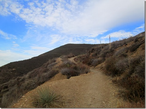
The climb up another peak:
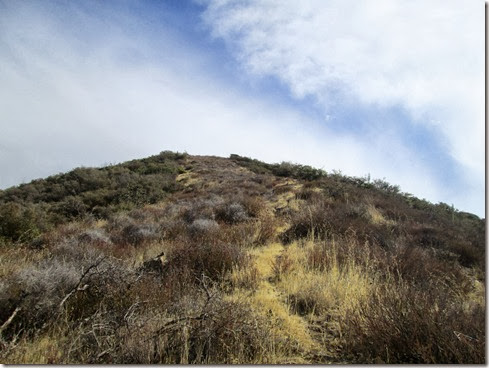
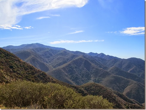
Its view:

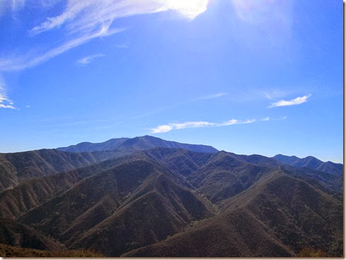
Not wanting to go back down the way I came up (I would fall for sure!), I ran along a ridge off of this peak to another smaller peak.  Again, no surveyor’s marker.  I bushwhacked my way back to The Main Divide knowing that I would have to turn back and try another day.  I had already run up every peak for two miles without any luck. 

Running back along The Main Divide, just about a half mile past the first peak I explored (the one with the bench), another ranger drove up.  He asked if I was okay.  I said I was, then asked, “Where the heck is Bedford Peak?”   He took out his GPS and said, “Gosh, its about 300 feet away from here.”  What???  Nearby, there was the peak I had already explored (the bench peak), plus the smaller one I skipped on the way in, and a peak at the top of the Silverado Motorway.  Tying up loose ends, I ran up the two remaining (small peaks) and searched again to no avail, for a surveyor’s marker. 

Well, judging by my garmin, the time had come to run back down and head home.  So, I kicked up my heels and took that 3.25 mile downhill switch back as quickly as I could.  I worked on my downhill speed, despite an aching foot.  I felt pretty good about my pace and progress running down that tricky/technical trail.  So what if I didn’t find Bedford Peak this time, I had a heck of a lot of fun racing down the Silverado Motorway.

Back at home, I washed my feet, put on The Sock and got on the internet for more research.  I found nothing different about Bedford Peak’s location that I had learned days earlier.  Either these hikers who wrote about it were wrong, or I actually did visit the peak.  I found a topographical map, and with my husband’s aid, determined that I was indeed on Bedford Peak this morning.  Still, I wasn’t convinced.  So, I researched some more until I hit the jackpot.  I found a number of write-ups that noted the bench on Bedford Peak.  One mountain biker even filmed the bench and posted it on YouTube.  And the surveyor’s mark.  Well, I learned about that too.  I found a picture where it used to be and learned that the marker had been “destroyed.”  I’m not sure exactly what “destroyed” refers to, but I have a feeling by the way the rocks were broken up, that it was actually taken.  Someone out there may be collecting surveyor’s markers.  Hopefully not. 

The climb:Running Silverado Motorway looking for Bedford Peak 11-10-2013, Elevation

Sunday, December 30, 2012

Closing In

I’m closing in on 2,012 miles for the year.  I’m getting a little beat-up and battered from falls, and I’m not dropping any pounds from the body.  BUT gosh darn it, I’m gonna hit that mileage goal.  And I’m having fun doing it.

It stormed all day yesterday.  Several runners dropped out of today’s scheduled group run for a 17 mile loop in Silverado Canyon.   Four adventurous runners did join me however, for a beautiful loop up Maple Springs Road to Four Corners, along the Main Divide, down Silverado Motorway back to Maple Springs.

The run was delightful.  Snow covered the ground in some places.  In other places, we slipped about on ice. I eventually fell on “black” ice and screamed like a little girl.  Seriously, like a little girl.  I was more stunned than anything else, and a little worried about my sunglasses as they crashed to the hard ice.

Views while climbing Maple Springs (a 7.5 mile ascent):

Time to celebrate at Four Corners:

Left to right:  Me, Janine, Hank, Dave, Conrado:

Moving on along The Main Divide:

Every time I run this loop (which is seldom), I’m always confused just when the Motorway trailhead is going to spring upon us.  It’s like that, suddenly there.  But until then, we’ve got climb after climb, plus some lovely down hills for several miles before we get there.  I think I told everyone today at least 3 times, maybe more (doh!) that “it’s just around the corner.”  New running friend Janine joked, “You say that one more time, I’m going to throw you off the mountain.” 

I hollered with joy when we finally reached The Motorway.  From there it was all downhill (except for that one little hill – LOL).  I took up the rear as usual, then got caught further behind when I needed to duck into the bushes.  Then, as I raced down trying to catch the group, I ate it BIG TIME.  When I say “big time,” I don’t mean that I was terribly hurt.  But I couldn’t fall and roll, which would have meant a lighter impact, for fear that I’d roll right off that single track and off the mountain.  Instead, I hit sprawled-out, face down, landing first on my wrists, then my knees.  I also remember my left elbow slammed down to the ground.  The impact was hard and it jolted me a bit.  Fortunately, I recovered fairly quickly and was off again, my ankle slightly aching from a roll as I went down.

Overall, today’s run was fantastic – great company, scenic views, chilly weather.  A true delight!

Running down the Silverado Motorway:

+4,386 / -4,409’Running Silverado Loop counterclockwise 12-30-2012, Elevation - Distance

Friday, November 16, 2012

Marking Bedford

Tomorrow is a big day in the trail / ultra running community around here.  Saturday begins Chimera – a 100 mile / 100 km race in the Saddleback Mountains.  My mountains.  No, I’m not running this beast.  But I am working it.  If you are running, and aren’t in bed yet, and are reading this post (though you probably should be sleeping :) say “Hi” when you see me!

I’ve had a great time witnessing the awesome amount of effort put out by the race directors and dozens and dozens of volunteers to pull this thing off.  I feel honored to be part of this.  I had my truck loaded with supplies for our station earlier in the week.  I’ve been receiving updates via e-mail over the past week from our station captain as well as the volunteer director (who happens to be running in this race too).  I’ve got everything stacked in the kitchen to take with me tomorrow for the long day ahead.

At one point during this prep, I was asked if I could mark the single-track Bedford.  I didn’t know Bedford, so I thought it wouldn’t be wise.  I declined.  Then I found out that Bedford is the trail that I call Silverado Motorway.  That’s when I thought, “No way!”  I’ve only run down that trail, and being on my “break,” I thought a three mile steep switch-back was too much.

But then it went on “unassigned.”  And I finally volunteered.  Heck, I could add it into my Friday run.  Double heck, I could do the Silverado Loop, that 17 mile loop that I’ve only run twice, but counter-clockwise.

With trail marking tape in hand, and a rain coat, gloves and head warmth shoved in my hydration pack, I headed up Maple Springs at about 9:30 this morning.   Reports said 30% chance of rain.  I wanted to run.  And I didn’t want to chance being out there in cold rain.  The skies were gray, the weather almost cold.  It was perfect for a three mile uphill run. 

I took a quick left onto Silverado Motorway / Bedford and began marking the heck out of that trail.  I marked it for the runner who has never been on Bedford, who is alone, and who is beginning to get paranoid about whether he/she took a wrong turn.  (I apologize now to the person who takes down the markers : )

Running up Bedford wasn’t as bad as I thought it would be.  Granted, I stopped several times to mark the trail.  The difficulty came after Bedford.  It was false summit after false summit after false summit.  Funny thing is, when I ran this loop reversed, it seemed like The Main Divide was mainly uphill.  Ends up, today, The Main Divide was mainly uphill, rolling hills yes – but add in those false summits – that’s difficult.  Fun difficult.  I could see for miles, and I didn’t see evidence of a single soul out there.  I felt completely alone in the mountains.  It was beautiful.  Not only for the eyes, but for the soul also.

Then, seemingly out of nowhere, a ranger truck drove by.  The driver slowed and casually said, “Everything okay?”  I was kind of glad that if I were to have collapsed on the divide, someone would have eventually driven by.

FINALLY, I made it to “Four Corners.”  I had ran 9.65 miles.  It felt like twenty, a lovely, lovely twenty.

“Four Corners” :

I lazily ran the 7 plus miles down Maple Springs to close up this loop.  By that time, people were driving up the mountain for an afternoon drive.  I saw one cyclist, two motorcyclists.  No runners.  Sure, this run took me longer than usual.  But I’m NOT TRAINING.  Plus, I was marking the trail for Chimera.  Yes!

Running Silverado Loop clockwise 11-16-2012, Elevation - DistanceRunning Silverado Loop clockwise 11-16-2012

Saturday, September 5, 2009

Maple Springs / Main Divide / Silverado Motorway

Woke at 4:15 this morning, on the road at 4:45. It was still dark, and unable to read the unassuming street signs, I drove right past Silverado Canyon on the way in. I made a u-turn on that lonely mountain road to arrive at the Silverado / Black Star Canyon intersection a little before 5:30 AM.

The weather was wonderfully cool as six of us (I'll refrain from saying six of us lunatics, or six of us crazies!) headed up Maple Springs Road. There was no downhill, or even a flat warm-up. The climb, though very gradual, began right away. Hey, I'm not complaining -- a cool breeze can make up for a lot. The climb was constant up to the Main Divide, but not terrible. That's not to say that I wasn't tired -- that I was. But I still had plenty of energy and the heat had not begun to bear down upon us.

Heading Up On Maple Springs Road


Maple Springs


Main Divide Road / Looking Back From Whence We Came


When the pavement ended, we ran a switch-back dirt road to the Main Divide, totalling a little under ten miles (I think). Daniel was waiting for Tom, Kelly and me, David and Larry had gone on ahead. When after wondering whether they had taken the correct turn, we saw two tiny figures in the distance, and so we were off too, headed for the ridge and that glorious trip down.

Meeting up on the Ridge (Tom Pointing Out Where We're Headed)


And We're Off!


The last part of the Main Divide Road (along the ridge) got pretty crazy for me. I found myself conserving water, which was not too smart. And the two hundred calories thus far wasn't nearly enough to make some of the steep climbs. My energy drained from me quickly as the sun now beared down hard. I relished even the tiniest bits of shade. And it was only after two hundred more calories, thanks to Kelly and Tom, did my energy slowly return. I told myself then -- no more rationing water. In fact, "you're in big trouble girl if you have any water left at the car."

Looking over other side of Santa Ana Mountains
(215 Fwy below, Lake Matthews in distance)


Me and It's-Not-As-Steep-As-It-Seems-Tom : )


Our Last Ascent!!


Group Photo-Op before heading down
2,000 Ft in Two Miles (Silverado Motorway)
Kelly, Daniel, Me, David, Larry


The trip down was a blast. Though tired as I was, I focused hard. Do not fall. DO NOT FALL. I tripped about three times, but no falls. That Silverado Motorway was a steep, steep, rocky switch- back (about 2,000 ft. in 2 miles). And though it was oh so beautiful, it was OH SO HOT. Tom, Kelly and I all ran out of water before reaching the bottom of the canyon. That was okay, because downhill, knowing the end is just around the corner, well, nothing beats that! Even in the blazing sun.

What a run. I'll say it again. What a run.

Miles logged this morning: 16.4

The Final Stretch (Car Is Just Around The Corner!)


The Fast Ones Waiting For Us As We Arrive


Elevation Profile (courtesy Tom, as well as 3 of the pics above)