TALES FROM THE TRAIL (AND SOMETIMES THE ROAD TOO)

Showing posts with label Laguna Beach. Show all posts

Monday, July 29, 2019

The Way to do Summer Trails

7/24/19 was my last hike for a while because of the weather. It's not a miserable sort of hot on the California coast (yet). But when you're out there hiking on exposed trails, the heat can get to you. Not to mention! There's lots of bees around in these coastal hills. Definitely not a big fan of bees. I like what they do and all, but I've been stung twice so far this summer. I try and ignore them and let them land and take off on me at will. It's when I interfere that I get stung. Anyway, I did not get stung by a bee on my last hike. But there were lots of bees. And there was a young man hiking up Mathis Trail (what a brutal hike in the heat!) who asked me to look at his back to see if he had been stung. Sure enough, there was a bee sting on his back. He didn't look too happy. And who would be -- the hike up Mathis is all uphill and entirely exposed. I, on the other hand, was hiking down Mathis in the middle of the afternoon. It was warm, but again, it wasn't a miserable sort of hot.

West Ridge Trail on the way to Mathis, Santa Ana Mountains in background:


I took my time on this hike because of the heat. I was aiming for about 6 miles, ended up with a little over 7 miles. There were a few people on the ridge. Just one other person on Mathis (the guy who got stung by a bee). And then I had all of Wood Canyon to myself. And I also had all of the climb out (Cholla Trail) to myself. It was a beautiful day. Having no time constraints made this trek utterly enjoyable. I freely stopped to take in views and cool down in the shade. That's the way to do summer trails. 

7.17 miles, 1,171' of elevation gain. From Alta Laguna Park in Laguna Beach: West Ridge / Mathis / Wood Canyon / Cholla Trail / West Ridge

The view from a hidden rock formation on Mathis Trail:
Wood Canyon:

There is where my heart is (hint: those mountains in the background. It's just too darn hot for me there right now).

Saturday, July 20, 2019

One Foot In Front Of The Other

Tuesday (July 16) I hit the trails pretty late in Laguna Beach.I can do this (despite the heat) because when I'm hiking, it seems like I can pretty much take any temperature, especially if I take time to cool down in the shaded areas. 

June Gloom is definitely gone (for the most part). We may be socked in during most mornings but that all burns off by afternoon on the Southern California Coast. Nowadays, I'm rarely on the trails, unless it's afternoon. Naturally, it was hot on Tuesday, but still, we haven't seen real heat around here for a while. I'm betting the temperature in the coastal hills was at most 85 degrees Fahrenheit (but it was probably a few degrees less). It can definately get much hotter.

I decided to go down Car Wreck Trail, which is quite steep and rocky.  My legs felt a little tight still from the prior two days of back-to-back short runs. Car Wreck Trail, even going down, was strenuous but it had breath taking views. And near the bottom, about where the car wreck is, the trail get's cool and shady. As you may know, shade is very important. Shade is the reason that I decided not to take up Mathis up out of the canyon. I opted instead for Rock It -- eventhough Rock It is probably more difficult than Mathis, there's little bits of shade! Wonderful shade.

Going down Car Wreck Trail


After a leisurely yet focused hike down Car Wreck Trail, I took Mathis to Coyote Run. Winding in and out from Wood Creek, there was plenty of shade on the trail. Not surprisingly, I didn't see anyone on foot. Most people in the middle of the afternoon opted for sandy beaches just over the hill. 

And then of course, I hiked up Rock It to West Ridge. One foot in front of the other is how I conquered that trail. Just like in life, one foot in front of the other. In all that strategy closed up a 6.19 mile lollipop loop with a elevation gain of 1,191. Much needed.

Coyote Run Trail

Rock It:

Monday, July 15, 2019

Goats at Top of the World!

Even though I love wandering about on trails and even though it is pretty much my medicine, nowadays I struggle with pushing myself out the front door. For many years this was not the case. I didn't relate to discussions on how to stay motivated. I was driven to wake early and put in hard miles several days a week. Of course, times were different then. I didn't work as much first off. And I was younger and less beaten down.

July 10, I believe it was, I took a mid afternoon hike in Aliso/Wood Canyons Wilderness. I had planned on 9 or 9.5 miles. I took a detour to Dripping Cave and meandered about elsewhere. I ended up with 11.53 miles with a moderate gain (1,500+ feet). About 3 miles in, I checked my email. That was a big mistake. Some disappointing news on the job front. This of course gave a whole new meaning to my hike. Good thing I chose (coincidentally) to hike up Meadows Trail. That's a darn good suffering trail there. Believe me, there's no better remedy for suffering than to climb a tough hill, in the heat. 

My route: Wood Canyon to Meadows Trail, Top of the World, West Ridge, Cholla, Wood Canyon. It was beautiful. It was therapeutic. As I mentioned already, I visited Dripping Cave, but what I didn't mention was that right after leaving the cave, a deer bolted across my path. That was exhilerating because she was loud and forceful. And she was gone in an instant.

Wood Canyon

Meadows Trail 


So, no matter how tough things may seem, it seems that I never wish that I didn't take that hike, or I didn't take that run, or that swim, or even that gym workout. This hike, despite my mood, was the best. And then I got these! These lovely goats at the Top of the World. 😊

 Goats at Top of the World!


Friday, February 19, 2016

From the Top Once More

Monday was a day off for me and my boys as well (President’s Day, where we observe George Washington and Abraham Lincoln’s birthdays). I celebrated by sleeping in. I believe that I made it all the way until 8AM. Wait. Now I remember, I actually set my alarm for 6AM (because that’s what I do), and I hit the snooze three or four times until I finally stopped it all together. Then after hearing my middle son wake and go out to the “man cave” I rolled out of bed around 8AM.

The weather was still rather warm on Monday. so, perhaps it was not the best idea to wait until 1PM before heading out for a run. Oddly, I chose once again to drive up Pacific Coast Highway to Laguna Beach to catch a trail along the ridge for another loop starting at the top -- except this time, I went against the gradual climb out, picking instead a steep, short nasty climb out at the end

I parked at a little known park called Moulton Meadows which sits high above the Pacific Ocean and Aliso Canyon. And I began my long gradual down hill run along Top of the World and West Ridge (which was more likely rolling down hills, meaning there were some up hills). I think I cursed the heat. Beeping heat! I really loved our cold weather. It’s too early to start feeling the heat.

Anyway, I ran Cholla Trail down into Wood Canyon and cheerfully greeted the shady groves that line the first mile and a half or so of this canyon. I was reallySAMSUNG CAMERA PICTURES digging this long gradual down hill stuff. But boy did I pay for it. From Wood Canyon, I took Meadows Trail on over to Mentally Sensitive, which I once re-named Psycho Path, and for good reason. I struggled immensely climbing this bastard of a trail. There really is no relief, and as you can see from the elevation chart below, the climb is steep as hell. Thankfully, it was short. But oh my lord. My pace was probably somewhere around a 40 mile minute. I may not take run that loop again for a while.

Jeez.

2 15 16aRunning down Cholla Trail into Wood Canyon:SAMSUNG CAMERA PICTURESStarting up Mentally Sensitive (Psycho Path!):SAMSUNG CAMERA PICTURESSAMSUNG CAMERA PICTURES1,271’ gained, 10.3 miles:2 15 16

Wednesday, February 17, 2016

Starting at the Top

Generally, I prefer trail routes that get the uphill over with toward the beginning of the run. I despise having to climb out to get home. But I also hate making the same old drive over and over again. I think I hate that more than climbing out at the end. So, this past Saturday, I decided to drive along the coast and drive to Alta Laguna Park, which is near the Top of the World neighborhood in Laguna Beach. Most often I begin my coastal hill running in the Canyons, Wood or Aliso Canyon, so it’s down hill back to the truck.

Starting off with 180 degree ocean views, Saturday I began my run on a down hill – a quick down hill, totaling just around two miles (down West Ridge and then down Mathis into Wood Canyon). From then on, it was uphill, a gradual uphill, which is why I chose this route. I thought that climbing out wouldn’t be so bad if the climb was gradual. And, so for the next FIVE miles I ran uphill, on an unusually warm weekend in February. It was tough. But, I hear that I am tough, so I guess it was okay.

Winking smile

2 13 16SAMSUNG CAMERA PICTURESSAMSUNG CAMERA PICTURES

2 13 16a

Route: Top of the World, West Ridge, Mathis Trail, Wood Canyon, Cholla Trail, West Ridge to Top of the World

Wednesday, September 10, 2014

Autumn PLEASE Move Your Arse

Tuesday

Dear Autumn:

Could you please, please, please move a little quicker and get here. 

Sincerely,

LaurenOnTheRun Winking smile

Out-and-back to Top of the World in Laguna Beach in dang hot weather.  6.67 miles run, 1,168’ elevation gained.

Friday, June 14, 2013

Test Run

I did not take a new pair of shoes out for a test run today.  Unfortunately, no.  I took my feet out for a test run today, more specifically, my right ankle.  I’m done wearing the boot.  But still, I wore one of those stretchy braces beneath my socks.  (I got it filthy with dirt.)

My ankle felt fine running the uphills and flats.  It was those downhills, especially on the way back that added a bit of pain.  My ankle may or may not have been ready for today (I’m going to be optimistic and say it was).  But dang it, I missed the trails badly.  I was actually having dreams that I could not run trails anymore, that I had to turn back on certain trails (that I’ve never seen in my waking life) because they were too hard.  Too hard!!! 

Aside from testing out the ankle, I also worked on a bit of form today as I ran the rolling ridge overlooking Laguna Beach.  One problem with my form has been that I lean my shoulders forward and look to the ground when running up hill.  This posture makes for tense sore shoulders and a reduction in speed.  During this afternoon’s run, I focused on keeping my head up, even with my hips.  And though I occasionally found myself looking down, I was convinced to keep looking forward when doing so I spotted my first rattler of the season.  She was a beauty.

Ready to run myself back into tip-top shape!

It seemed that I actually made eye contact with this rattler as I ran toward her to snap this photo.  She appeared annoyed. (On the way off this single track, I came upon two lovely young, very young ladies, making their way up.  I warned them to be aware, “I just saw a rattler.”  Upon hearing this, they both SCREAMED, and ran back down the single-track.  I felt badly for scaring them and gave the ladies a quick lesson in rattlers, ie, keep aware, give them their space, etc.  I was glad to see the two turn around and make their way back up. Smile

West Ridge:

Top of the World:

The Profile:

Running Cyn Vistas to TOW and back 6-14-2013, Elevation

Sunday, September 16, 2012

I’m Not Proud (But I Didn’t Have A Choice)

After spending the morning with my family, I drove off to the coastal hills for a 1:00 PM trail run to finish off this “hard” week.  When I arrived the gates were closed, yet cars were parked in the lot and along the road.  People were also turning around their cars and driving back the way they came.  I pulled up next to the ranger who stood at the gates.  She told me the park was closed for everyone coming in.  There was a fire in Laguna Beach.  It wasn’t out of control.  But if it did get out of control and they had to evacuate the park, they didn’t want the trouble of evacuating too many people. 

As this kind woman spoke to me, my brain was elsewhere, thinking:  “Please stop talking.  I get it!  I just need to somehow sneak into the park, then I can stay.” 

“Okay, thank you.”  I smiled, turned around and drove off.  I thought of all the park entrances and decided that Top of the World would be my best bet.  So, I went on my way, taking about a half hour driving into Laguna Beach.  I could see smoke in the distance.  Then suddenly the traffic came to a near halt.  At this point I figured that the rangers could easily block entrance at Top of the World.  Then I remembered a way in that most people don’t think about.  There is a park in the neighborhood that Mentally Sensitive ends near.  So, off I was, driving approximately 5 miles an hour to my destination, hoping I could sneak into Aliso/Wood Canyons.  I had to run trails today, especially so close to The Taper.

I felt sneaky.  I felt selfish.  I didn’t really like what I was doing.  But I really wanted to get in this run.  And besides, I tried to justify, if anyone’s going to be safe and know what to do if trouble arises, it’s going to be me.

Before I continue, I should go into a little background for people who don’t live here.  October is fire season in California.  It has always been (Okay, it’s not exactly October, but it’s close).  Some Octobers we escape without fires.  Other Octobers we get clobbered.  A few years ago, my parents were evacuated in San Diego county from wildfires that burned down several neighborhoods.  Also, some years back in Orange County, we had some pretty bad fires, closing some mountain trails for a year or more. 

I remember as a child living near the foothills of the San Gabriel Mountains (L.A. county), seeing those mountains ablaze again and again.  Ashes used to fall down like snowflakes in our backyard.  Our car windows were coated with ash.  I guess you probably got the point that October is fire season, and that we are a little paranoid about it around here.  But more so, we are paranoid about it in Laguna Beach.  In 1993, during my senior year in college, Laguna Beach had a firestorm like no other that I can remember.  Other areas got hit too.  But Laguna Beach only has 3 ways out – Highway 1 South, Highway 1 North, and Laguna Canyon Road. 

We lived pretty close to the Dana Point / Laguna Beach border at the time.  Standing outside our apartment, we could watch for hours, miles and miles of headlights trying to escape the city.  A bright orange glow shined at the tops of the hills.  Ashes rained down everywhere.  Entire neighborhoods burned to the ground, 366 homes total and 17,000 acres in Laguna Beach alone.

The local community has very good reason to be paranoid about fires.  This is why I’m not proud of circumventing this paranoia so that I could run. 

The hills were smoking as I drove on today toward the park near Mentally Sensitive.  Dozens of firemen, dressed in heavy gear climbed the hillsides in 90 F degree heat.  A helicopter occasionally flew by to drop fire repellant. 

I finally made it to the street I needed.  It was blocked by police.  So, I drove around to get to the other side of the smoldering hillside.  I parked along the street, happy to see no law enforcement or fire crews, and ran into the city park toward Mentally Sensitive.  Before I arrived to the trail, I spotted Meadows Trail in the distance.  Three fire trucks were parked at Meadows’ entrance.  So, I wouldn’t be running down Meadows.  Thing was, Mentally Sensitive’s trailhead is visible from Meadows.  And so, I bushwhacked my way down the hillside so that I could reach my trail unseen lower down the slope.  Thing was, when I came upon my trail, I could still see the firemen.  I don’t know if they could see me, or if they even cared.  But I ducked, yes, I’m not proud.  I ducked as I ran along the trail.  If only I wasn’t wearing my dang orange hat.  Eventually I had to stand erect, the trail was so steep.  When I did, I didn’t look back.  I ran down Mentally Sensitive and didn’t ease up until the trucks were no longer in my sight.

I was in!  And unless they evacuated the park, I was going to stay in.  But I didn’t see anyone for at least three miles, so of course I worried that they had indeed evacuated the park.  Finally, I came upon some mountain bikers.  Later I came upon small groups of hikers, so I felt confident the rangers had not evacuated.  Unless the same ranger who told me they were closed saw me, and remembered me (dang orange hat), I was home free!  Just to make sure, I took a single track as soon as I could.  I ran Coyote Run, feeling pretty good physically.  But the heat was tough. 

In all I ran a ten mile loop.  I was supposed to run 12 miles.  I goofed, because I forgot to look at “The Plan.”  Therefore, I came in about 2/3rd’s of a mile short of my 72 weekly miles.  (My oldest son said that I should just run around the block, I laughed at that notion – smart boy, but this Mama’s done running for the week!).

Shhhh (please).  Running down Mentally Sensitive:

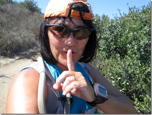
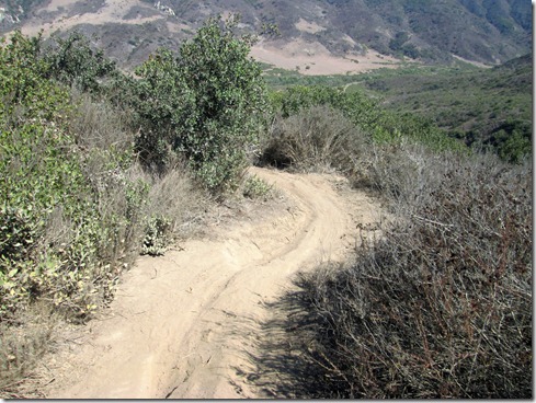
Finishing up Meadows, headed into Wood Canyon:
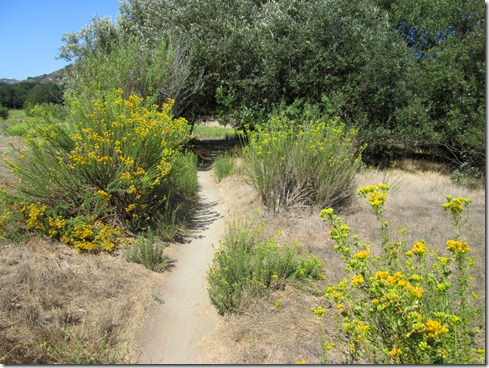
Coyote Run Trail:

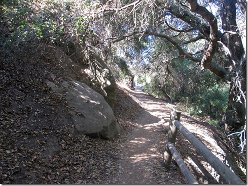
Running up Rock It Trail:

Headed back to my truck:
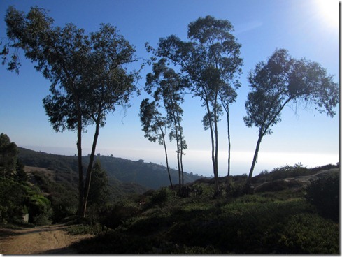
Wednesday, March 7, 2012

Meadows x 3

With little time and little gasoline, a mountain run was not “in the cards.”  I needed to make this morning’s miles COUNT.  By “count,” I mean difficult. 

I decided on hill repeats up Meadows – yup, the trail that used to give me great anxiety, the trail that I feared!  I’ll tell you one thing that running up West Horsethief does.  It dwarfs even the toughest hills on my coastal trails.  Even Meadows.  I ran up and down it three times this morning.  I could have done more.  But I had to get back home for chores and get ready for work.

After about a 2 mile warm-up, I arrived at Meadows:

A Magical Entrance to Meadows:

Heading toward the first climb up – this is why they call it Meadows:

First Arrival to the Top of Meadows (Overlooking Laguna Beach):

First trip down Meadows (Saddleback Mountains in background):

Running UP Meadows #2:

Arrival to Top of Meadows #2:

Going down #2:

Going up #3:

Arrival to Top of Meadows #3:

Heading back to Wood Canyon:

Profile:Meadows hill repeats