Arroyo Trabuco Trail:
The video clips:
Saturday morning (9/1), I slept in (as I do lately – I still have not recovered from my 17 days off from work). I believe that it was about 12:30 when I took off in my truck for Aliso/Woods Canyon. Being that the weather was damn hot, there were plenty of parking spaces on the street outside of the ranger station. This meant that I did not need to pay for parking, and as I cannot afford yet to even repair my truck, that came as a welcome (despite the very small amount our county parks require for parking – it all adds up!). As I prepped outside my truck, a woman sitting low in a car parked next to me hollered out to a passer-byer, “Is there a river in that park?” No, the passer-byer didn’t see a river. Hmmm. A river? Oh Boy. that was it on the subject, the passer-byer didn’t mention the creeks (which I did mention to the two ladies in the car who were smoking hashish out of a glass pipe).
So, Aliso/Wood Canyons has two year round creeks running through the park. One creek is in Aliso Canyon and the other in Wood Canyon. The two creeks meet it seems at perpendicular angles. Wood Creek dumps into Aliso Creek, which runs all the way to the Pacific Ocean rat Aliso Beach in the city of Laguna Beach. In all the years that I have been visiting these canyons, I have never seen either of these creeks dry (though low they can go!). And though they can flow quite heavily, I would never call them rivers.
Like I have already mentioned, it was dang hot out there in Aliso Viejo on the first day of September. Even so, there were your usual amount of warriors out trekking across the trails. One group that I saw off and on, was a group of 3 or so dads and ten or so little guys (probably about 10 years old) riding their way up Wood Canyon. I also got to check in with some of the burned area. There’s new growth already in some areas. The fire fortunately did not ravish Wood Canyon (but I have not seen Dripping Cave or Coyote Run trails yet because they are closed).
I didn’t see any of the large animals (like coyotes or deer), but I saw plenty of rabbits, road runners and lizards. And on the topic of lizards, I saw several horned lizards, which are a new finding for me in these canyons. Then toward the end of The Big Loop at Aliso/Woods Canyons, I came up on a baby gopher snake. It was a beautiful little creature, which I’ve pictured further down below.
Wood Canyon regrowth:
Anyway! The first 4.5 miles were delightful. They were hot, but much of Wood Canyon provides good shade. The 4.5 mile marks the end of Wood Canyon. After marching up Cholla Trail, I took the rolling hills of West Ridge to Top of the World in Laguna Beach. I do not recall the time that I arrived at Alta Laguna Park, but I do recall that the weather was beginning to change. The sun still shined brightly, but there was a cool onshore breeze coming in. What bliss! The onshore breeze is the most wonderful thing about living on the coast. So, that made the remainder of my hike just utterly pleasant (not to mention that fact that I had very few inclines to deal with after the half-way point.)
The weather changed at the 7 mile mark which is Top of the World, or rather Alta Laguna Park in Laguna Beach. The breeze got a littler cooler and each time lasted a little longer. And so, I trekked through the Laguna Beach Top of the World neighborhood to enter the park again over in Aliso Canyon. On the way, I passed a pasture of goats surrounded by a make-shift electrified fence. I fought against an urge to touch the fence to see just how much the jolt would be. On meadows, I met a gopher snake, and also stopped in more than one place to listen to the wind blowing through the trees.
It was almost like a different day when I arrived by at the truck. It was like a cool autumn and not a hot summer day like when I started.
12 miles, 1,319’ feet elevation gain
 Friday, March 18, I headed out to Wood Canyon after work around 1PM. With my normal quick out-and-back in mind, I headed up Cholla, and ran along West Ridge to Top of the World. But I had a lot on my mind and didn’t want to return home so quickly. So, after running back down West Ridge, I turned off at Mathis and headed down an old technical favorite, Car Wreck Trail. It’s a tricky trail, rocky and steep, named after a wrecked car toward the bottom. And it helped me a great deal, as I needed to focus so closely on the trail, that I didn’t have time to ponder the craziness in my mind.
Though it’s tough, Car Wreck Trail is beautiful:
Car Wreck Trail eventual turns into another (I think it’s called Thousand Oaks Trail?) which in turn dumped me right back out onto Mathis, At the creek crossing at Mathis, I took a seat on the rocks and got caught up in the sound of rushing water. It had a great calming affect. Not sure how long I stayed, but it was a while, possibly twenty minutes.
And then I was off again along Wood Canyon, and I must have noticed five different snake tracks. One of them looked extraordinarily large. Sorry to have missed that one!
The wind picked up further into the canyon, and the grass fields swayed in waves. Mesmerized by the flow, I abruptly stopped along the field and watched the fields of grass move up and down like an ocean. It nearly took my breath away.
Monday was a day off for me and my boys as well (President’s Day, where we observe George Washington and Abraham Lincoln’s birthdays). I celebrated by sleeping in. I believe that I made it all the way until 8AM. Wait. Now I remember, I actually set my alarm for 6AM (because that’s what I do), and I hit the snooze three or four times until I finally stopped it all together. Then after hearing my middle son wake and go out to the “man cave” I rolled out of bed around 8AM.
The weather was still rather warm on Monday. so, perhaps it was not the best idea to wait until 1PM before heading out for a run. Oddly, I chose once again to drive up Pacific Coast Highway to Laguna Beach to catch a trail along the ridge for another loop starting at the top -- except this time, I went against the gradual climb out, picking instead a steep, short nasty climb out at the end
I parked at a little known park called Moulton Meadows which sits high above the Pacific Ocean and Aliso Canyon. And I began my long gradual down hill run along Top of the World and West Ridge (which was more likely rolling down hills, meaning there were some up hills). I think I cursed the heat. Beeping heat! I really loved our cold weather. It’s too early to start feeling the heat.
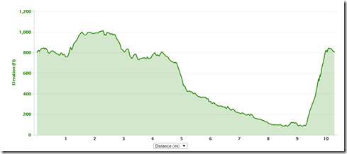
Anyway, I ran Cholla Trail down into Wood Canyon and cheerfully greeted the shady groves that line the first mile and a half or so of this canyon. I was really digging this long gradual down hill stuff. But boy did I pay for it. From Wood Canyon, I took Meadows Trail on over to Mentally Sensitive, which I once re-named Psycho Path, and for good reason. I struggled immensely climbing this bastard of a trail. There really is no relief, and as you can see from the elevation chart below, the climb is steep as hell. Thankfully, it was short. But oh my lord. My pace was probably somewhere around a 40 mile minute. I may not take run that loop again for a while.
Jeez.
 Running down Cholla Trail into Wood Canyon:
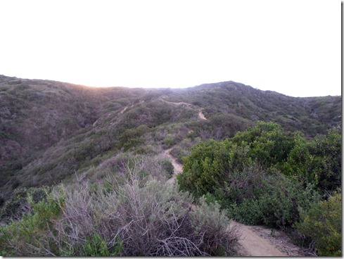
 Starting up Mentally Sensitive (Psycho Path!):
 1,271’ gained, 10.3 miles:
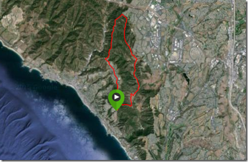
Generally, I prefer trail routes that get the uphill over with toward the beginning of the run. I despise having to climb out to get home. But I also hate making the same old drive over and over again. I think I hate that more than climbing out at the end. So, this past Saturday, I decided to drive along the coast and drive to Alta Laguna Park, which is near the Top of the World neighborhood in Laguna Beach. Most often I begin my coastal hill running in the Canyons, Wood or Aliso Canyon, so it’s down hill back to the truck.
Starting off with 180 degree ocean views, Saturday I began my run on a down hill – a quick down hill, totaling just around two miles (down West Ridge and then down Mathis into Wood Canyon). From then on, it was uphill, a gradual uphill, which is why I chose this route. I thought that climbing out wouldn’t be so bad if the climb was gradual. And, so for the next FIVE miles I ran uphill, on an unusually warm weekend in February. It was tough. But, I hear that I am tough, so I guess it was okay.
![]()
Route: Top of the World, West Ridge, Mathis Trail, Wood Canyon, Cholla Trail, West Ridge to Top of the World
Sunday’s Route: Wood Canyon, Meadows Trail, Top of the World, West Ridge, Cholla Trail, Wood Canyon. 9.78 miles (15.74 km) , 1,163’ (354.48 m) elevation gained.
 Despite my wacky schedule, I was able to end the week with a long(ish) Sunday run in Aliso/Wood Wilderness Park. My feet didn’t hit dirt until about 2PM. And that was okay. I took the canyon trail first, full of shade, so I wasn’t bothered by the heat. I did run up on one rattlesnake though. But I was too slow with the camera to catch a picture before he slithered off into the brush.
Though it was warm (we’ve seen temperatures in the 80’s lately!), I did get some nice cool breezes. And even with the heat, it’ still not the same as the summer heat. Somehow, it felt like winter heat, and that was soothing and wonderful.
By the time I reached Meadows Trail, which is pretty much up, up, up (switchback thankfully), the temperature had cooled tremendously. I was able to march up that incline considerably faster than usual of late, as there were some hikers I wanted to pass. And I did. ![]()
Reaching the top of Meadows was a great relief, as aside from the minor uphills along the way, it’s pretty much down hill from there. By the time I made it to Alta Laguna Park to re-enter the wilderness park, the temperature was ideal – coolish-warm, which is more on the cool side, but warm enough to not need a jacket. I packed lightly for this run, but didn’t even need all the water that I did carry along. I so love packing lightly on the fluids. One of the wonderful things about running in the winter!
Anyway, I finished off not terribly strong, but not terribly beaten either. Made it home before dark. I was delighted, so much so, to not experience any plantar fasciitis pain.
Meadows Trail: Looking back while climbing Meadows Trail:
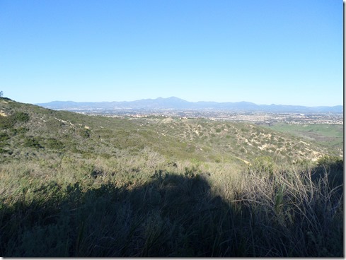
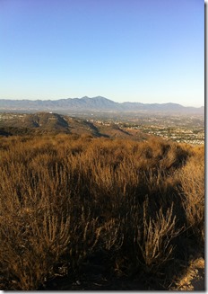
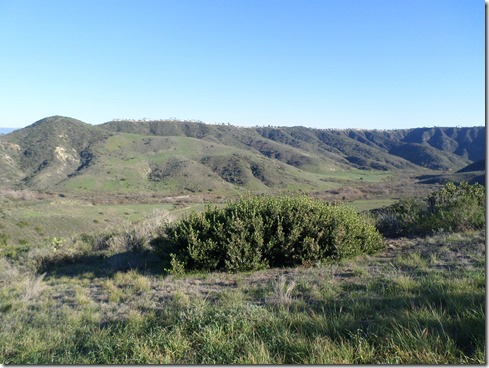 Top of Meadows Trail, facing Saddleback Mountains:
 For several months now I have been been feeling lethargic, and growing more so lately. I have no motivation to do anything that requires too much exertion. Though I train at the gym about five days a week, I can’t manage to move very quickly or for very long. It’s a big bummer, more so I think, because this fatigue affects me mentally. I feel weak. And I hate that. Hate it!
I decided recently to research premenopausal symptoms, as I have the joy of going through that the past six months or so. And while I did not find the term lethargy in my research, I did come across the terms “extreme fatigue” and “crashing fatigue,” as common symptoms. Aha! I guess that makes me feel a little better. At least there’s an apparent reason to my lethargy. But the more I throw the terms around in my mind, the more “CRUSHING fatigue” seems to fit my what I’m experiencing -- it’s crushing my physical and mental well-being, it crushes my spirit.
This past Sunday evening, I decided to get out and just force myself to put in some trail miles. I took a little run along West Ridge to Top of the World, which isn’t exactly flat. And I must say, I felt pretty miserable in the beginning. Actually, I never really felt “good” in the sense of feeling physically or mentally strong. Once I decided that it did not matter what time I finished, that it was okay to finish in the dark however, I did enjoy the coastal scenes, the gentle off-shore breezes and little evidences of wildlife like bunnies scurrying across the road and stink bugs sticking their heads in the dirt. I hiked some, and I ran some. My legs felt like heavy awkward boards when I ran. They felt a little lighter when I hiked. I guess it would be prudent to take on something with not so much elevation during this “crushing fatigue” period. But I can’t help it. I’m just an elevation junkie.