TALES FROM THE TRAIL (AND SOMETIMES THE ROAD TOO)

Showing posts with label Cleveland National Forest. Show all posts

Thursday, December 8, 2022

Out of Hibernation

IMG_0532December 3rd, my youngest son’s 18th birthday, I took a nice ten mile hike up Black Star Canyon, to one of my favorite easy to get to, out in the open, secret places. What’s the occasion? Nice cold weather was the occasion. It was time for me to come out of hibernation. I am awake! What a great hike to celebrate awakening. After a day like that I wondered (out loud) why I’m not out there every single day! I get that much peace from the trip. I felt so full of joy at one point that I burst into a spontaneous run. I stopped myself from that silliness pretty quickly though since it’s been a while. I’m not practiced – last thing I need is a face plant. My arms only recently recovered from the last fall in December 2021. (Excuses, excuses).

I love Black Star Canyon. Yes, the base is well travelled and in places vandalized with spray paint. That’s sad. And yes, it’s mainly all truck trail (with a few single track turn offs available here and there). Once you make that turn 2.5 miles in and start the climb, there’s so much to see up there, even close to the road. Black Star Canyon is a beautiful place with a huge local history (which explains the legends of its haunting). On that note, I do find Black Star Canyon haunting, but not by ghosts. 

IMG_0538IMG_0544IMG_0559IMG_0560IMG_0584IMG_0589IMG_0591IMG_0595IMG_0598IMG_0641IMG_0644IMG_0662

Sunday, March 1, 2020

Laurel Springs -- Check.

Last Friday, February 21,  I got out for some much needed trails (so few and far between!). For this hike (& run), I was fortunate to have a friend come along and so my goal was to finally find Laurel Springs. I have passed the trail marker along Harding Truck Trail dozens of times. And I have even taken the Laurel Springs trail down a short ways, only to turn back because of the heat.

We took off out of Tucker Wildlife Sanctuary in Modjeska Canyon at about 9am and headed up the huge climb, passing Flores Peak on the way. The climb up Harding is STEEP -- Steep and gorgeous, which helps keep your mind off the climb. Actually, good company and conversation is more what kept my mind off the climb. 

It was a beautiful clear day. Spring flowers were showing themselves along the edges (orange poppies and purple lupin). We did not see a single other person on foot. But we did see the fire department -- they were out grading Harding Truck Trail. 


At exactly 5 miles on my sports watch, we found Laurel Trail, which is no longer marked. It starts off downhill and continues that way for about a 1/2 mile (at most!).

We found Laurel Springs pretty quickly after taking the trail. It's a downhill single-track hike, no more than a 1/2 mile as previously mentioned. Overall, reaching the springs was anti-climatic to say the least -- just a dribble. But the area was overgrown which made for a cool resting place. And the trickle sound of the water was lovely. 


After the anti-climatic Laurel Springs, we hiked back up and layed back on a concrete block structure tucked off of a side trail and looked up at the sky. This was the serene view (picture below). What a lovely view to take in while listening to the sounds of silence. Great medicine! We ran much of the way back. But then we took a little detour into Harding Canyon to scout out a future hike. Looking forward to that.


Running Back with Laurel Bay Leaf in my vest pocket (love the smell!)


11 miles,
2,778' feet of elevation gain (done pretty much in the first 5 miles!)

Wednesday, August 21, 2019

Point to Point Hike (San Juan Trail)

It has been much too long since I last hit the trails (8/10/19). Eleven days ago to be precise. And then school happened -- my two youngest boys went back to school, and so did I. It all came like a whirlwind and I am off kilter just a bit. I am back to teaching at one of my schools, and at another beginning next week. Gosh, it all came like a fast. I still feel a little out of sorts. Summer vacation was like a race to me, a race to check things off my list. Well, the end of my summer vacation has ended, and I did get some things done. I so feared that I would not. And I was constantly critical of myself over whether I was doing enough. Well, I didn't get everything done. But I certainly did enough. And the most important things, they got a check mark. 

I'm also back to working on Old Goat races (more about that later), so my last hike was to measure San Juan Trail in it's entirety, from Blue Jay campgrounds down to Hot Springs Canyon. You can bet in the middle of the summer, the only way I was going to do this hike was to do it one way -- the downhill way. 

Early that morning (but not terribly early -- 8:30), I met a friend of mine, Jose, and his neighbor, Pedro, at Hot Springs Canyon Road. We drove into the canyon and parked Jose's car. Then the guys got in my truck and we drove to the top of the mountain and parked in Blue Jay campgrounds before setting out on San Juan Trail. The trail was beautiful with views going for miles and miles, as far as the Pacific Ocean. And can you believe it, we were the only people on them. We had some shade, especially in the first third. But after that, the trail is pretty exposed, and the weather was hot. Hot but bearable. There was a tad of uphill, but overall the 12+ mile trip was technical downhill. The fun stuff!


About five miles down, Jose realized that he had left the keys to his car in my truck. Oops. This was indeed a situation being that it was his car down at the bottom of the mountain that we were going to drive back to my truck. I was not so concerned about this. To me, this was just part of the adventure, and I enjoyed the rest of the trip without a thought to the matter. One thing for sure, I wasn't willing to hike five miles uphill back to my truck. I just trusted the guys would figure something out, and if not there was always my husband or son that I could call (if I could get a signal that is). 

Somewhere in the final switchbacks (look at that lovely pictured below!), Pedro got a cell signal and phoned a friend to meet us at the fire station on Ortega Highway and Hot Springs Canyon Road. We picked up our pace some at that point because we still had quite a ways to travel to the station. I estimate the friend who was driving out to rescue us was about twenty minutes away. We on the other hand were about 2 miles from Jose's car and another mile to the station (which means that our hike was not 12+ miles, it was 13+)

Just about the last tenth of a mile before the bottom of  San Juan Trail, I slipped in the loose dirt on a turn in the trail, and then on my fall, slipped again. I felt like the top half of my body twisted one way, while the bottom half twisted in the other direction. It was quite a jolt. I recall Pedro rushing in to help me up but I just couldn't really focus at the moment. It's like I had to take a moment to process the pain, accept it and then finally get up and get going. Once I did that, I just had to pretend and ignore the pain until I got home and could deal with it. I should point out that I was confident that my injuries were not serious, no broken bones or anything like that. At the worst, I felt I could have torn some tendons in my foot, as the twist and subsequent feeling in my foot felt very similar to the time I tore tendons in my foot on West Horsethief Trail. 

Every hike or run is an adventure, isn't it? Pedro's friend was waiting for us at the station. I drove up the mountain with him, leaving the other two behind because his truck had only two seats. I wish that I remembered his name because he is definitely worth mentioning. What a good friend he was to Pedro. He told me, and I could tell that he was uncomfortable driving up that windy mountain road. I believe he said that it had been 15 years since he had driven up Ortega. I didn't blame him. I used to be scared to death of driving to the top of the mountain (I'm still a tiny bit scared). Anyway, Pedro's friend spoke little English, and I spoke even littlier Spanish, so our communication was challenging. He had no idea what he was in for, and yet he did it with a friendly smile. He got me back safely to my truck. And we both drove back down to the fire station on Ortega Highway and Hot Springs Canyon Road to meet up with the other guys.

It really was a lovely hike. San Juan Trail is challenging, even on the downhill. I was sore for a few days after my fall. When I dress for work now, I make sure that my dress covers my knees so that the scab doesn't show. It is healing up quickly now though. And the scrapes on my arms are barely noticeable. 

All's well that ends well. 


Sunday, March 17, 2019

Ortega Falls (Oops, Not Ortega Falls, which is about a mile further up Hwy 74)

Thursday my husband and I had AGAIN planned to hike Caspers to the hot springs. However, the trails we planned on taking were still closed. So, we drove up Highway 74  to the lot across the street from the candy store. There is a lovely short-short hike up called the San Juan Loop that takes off from the parking lot and winds around to end in back in the lot. It's only 2.2 miles long, but you can add more by hiking down to the falls. Our total hike ended up at 2.7 miles, and boy did we see some falls. It has been quite some time since I have seen Ortega Falls flowing -- can't recall the exact date, but it's been years. This hike is a must do after the rainy season. The added bonus is that it is short, so you can do it as one of your first hikes working up to longer ones. The trip down to the falls is a bit tricky, but definately can be done. Just do it with care.

The first sight of some falls -- looking down from San Juan Loop
 Hiking down & getting closer
 Arrived!
 After hiking back up to San Juan Trails, we spotted this one a little further in


Friday, March 15, 2019

Hot Springs Canyon 3X

I have come to conclude that it’s a good thing that the state and county parks have been closed so much lately “due to wet and muddy conditions.” I was getting so annoyed at OC Parks, but now I am fine. Really, I am fine. All these closed parks have lead me to a wonderful revisit -- a revisit to Hot Springs Canyon. And what an unexpected delight this has been.

Hot Springs Canyon is toward the bottom of the mountain off of Ortega Highway (In the Cleveland National Forest on the Orange County side). The turnoff is by the fire station and the same road that you take to LazyW Ranch. Old Goat’s Chimera (100 mi. race) has an aid station in this canyon. It’s where the runners come off a long 12 mile downhill on San Juan Trail. And then they must turn around and repeat those 12 miles back into the Blue Jay campgrounds. I have frequently travelled San Juan Trail over the past decade. But I almost always stay toward the top of the trail and go off on other junctions like Chiquito Trail and The Viejo Tie. A couple of times I have ventured up San Juan Trail from Hot Springs Canyon. Once, some years back, I ran up the trail from Hot Springs Canyon to Cocktail Rock. One thing for sure, during the summertime, San Juan Trail is a bear. It can get brutally hot, heat stroke kind of hot, if not taken seriously. It’s completely exposed until you get in pretty close to the campgrounds. So, you’ve got about 7 or 8 miles of uphill sun beating down on you if you want to make the trip on San Juan Trail from Hot Springs Canyon into Blue Jay campgrounds.

Oh, how I have digressed. My journey back to Hot Springs Canyon began at the beginning of this month -- March 1, in fact. I got a really late start because I had to pull over and make some unexpected phone calls. It may have been as late as 1 pm before I arrived to Hot Springs Canyon, the location I chose because it was semi-close and all my local trails were closed. I meandered a bit about the creek, which was clear and rushing. Then I gave myself two hours up before I needed to turn back to make sure that I’d get in before dark (we hadn’t changed the clocks yet). The weather was cool and breezy, the skies gray. Little fields of wildflowers were splattered all over the slopes. And moss and ferns were wrapped around boulders and rocks in the shady areas. Wow. This was no summertime San Juan Trail. This was beautifully cool weathered- springtime San Juan Trail. 8.10 miles on this hike; 1,713 elevation gain.


Trip number two into Hot Springs Canyon this month was unplanned. Thursday, March 7, my husband and I had planned a hike in Caspers Park to the San Juan Hot Springs (we have never been). I should have known, because Caspers is part of the county park system, that it was closed due to “wet and muddy” conditions. So, we drove a few miles and turned into Hot Springs Canyon hoping we could find a way to the hot springs from that location. Turned out that the entire perimeter of Caspers is fenced. We did find a spot to squeeze through, but being that the place was so heavily fenced and plastered with no trespassing signs, we decided to squeeze back through the barbed wire fence and did a short creek hike instead. We crossed the creek several times before reaching LazyW Ranch. We took in every cabin (as close as possible). Everything was clean and green. Some of the cabins had the creek flowing just past their front doors. What a lovely spring canyon. 4.03 miles on this hike, plus a little more walking around at the Tree of Life Nursery down the road a bit. (Wonderful nursery with all California native plants).


The very next day, Friday March 8, I got back out to Hot Springs Canyon. I had five hours. I really needed to get back to the car by 4pm so that I could bring my son to an appointment. (Just in case though, I had left directions on the kitchen counter so that my husband could bring him if I didn’t get back in time.) My goal was Cocktail Rock, which I estimated was around 6 miles away (uphill).

Well! The day was absolutely lovely with big puffy clouds and blue skies. Spring flowers were bursting all over the place. I could see down to the Pacific Ocean and for miles into the Cleveland National Forest. It really was amazing. But my time was not good. Cocktail Rock was slightly further than I expected. The weather was super cold at the rock, and the wind began to pick up. It took me slightly more than 3 hours to arrive there, and I wasn’t going to turn around and go straight back. I did recorded some video, took in the scenery. By this time though, I basically had 1 hour and 45 minutes to make the trip back, which I could conceivably do if I ran it. Funny thing was, my phone rang when I was hanging out at Cocktail Rock (did not expect any service there!). Learning that I had cell service, I gave my husband a call to let him know that he would have to take our son if I didn't make it in time. I had fun running back (as it was basically all down hill). But the trail got too technical in some parts, and being that I’m not really practiced at running this level anymore, I slowed it down during those portions.  I did not make the return trip in 1 hour 45 minutes. But I was close. It took me just a little over two hours. Total distance: 13.11 miles, 2,546’ of elevation gain. And that is why Hot Springs Canyon 3 times!


Thursday, September 15, 2016

Maple Springs!

More than two years ago, Silverado Motorway (AKA Silverado Trail, Bedford Trail) was set aflame by a local resident who apparently was attempting to keep wild animals out of his yard. The fire burned about a thousand acres, all mainly up the Motorway. But the Silverado Motorway trailhead is just about fifty yards into Maple Springs Road. Thus, the fire closed down Maple Springs Road in its entirety. That was the first year I coordinated volunteers for Chimera. The 100 mile course had to be altered, which was a minor inconvenience. More importantly, Maple Springs Road, which zig-zags up Silverado Canyon to “Four Corners,” where The Main Divide in two directions, as well as, Harding Truck Trail meet, was completely and totally closed to all traffic. CLOSED. More than TWO years. I cannot tell you how much this weighed on my heart, as it seemed the longer they kept that gate locked and closed signs posted, the more Maple Springs became the only place I ever wanted to be. Go figure.

For a while there, I telephoned the ranger station to inquire when they’d open up the road again. First it was in September they’d open, then in the spring, then the following fall, etc. Eventually, I gave up hope and stopped calling. Part of me wondered if the powers-that-be wanted to keep the road closed for good, perhaps to preserve the land from us trompers.

Last week, I received the glorious news via a Facebook post from a fellow trail runner who lives in Silverado Canyon (perhaps you know him, Greg Hardesty), that Maple Springs is now open.

Be still, my beating heart!

SAMSUNG CAMERA PICTURESAnd so it was, last Sunday (9/11), pretty late in the morning, I drove one hour from my seaside town to the tiny, yet wonderful town of Silverado in the Saddleback Mountains. The parking lot at the Maple Springs trailhead was full which was not a surprise -- I’m sure lots of people have longed for Maple Springs over the past two years.  But I drove on past that, winding my way up a single lane paved road, relatively crowded with hikers, mountain bikers, bikers and runners. Three and ½ miles in, I rested my truck in a small dirt turnout, just where the paved road ends. And then I strapped on my hydration pack, and made my way up Maple Springs Road to “Four Corners.”

SAMSUNG CAMERA PICTURES
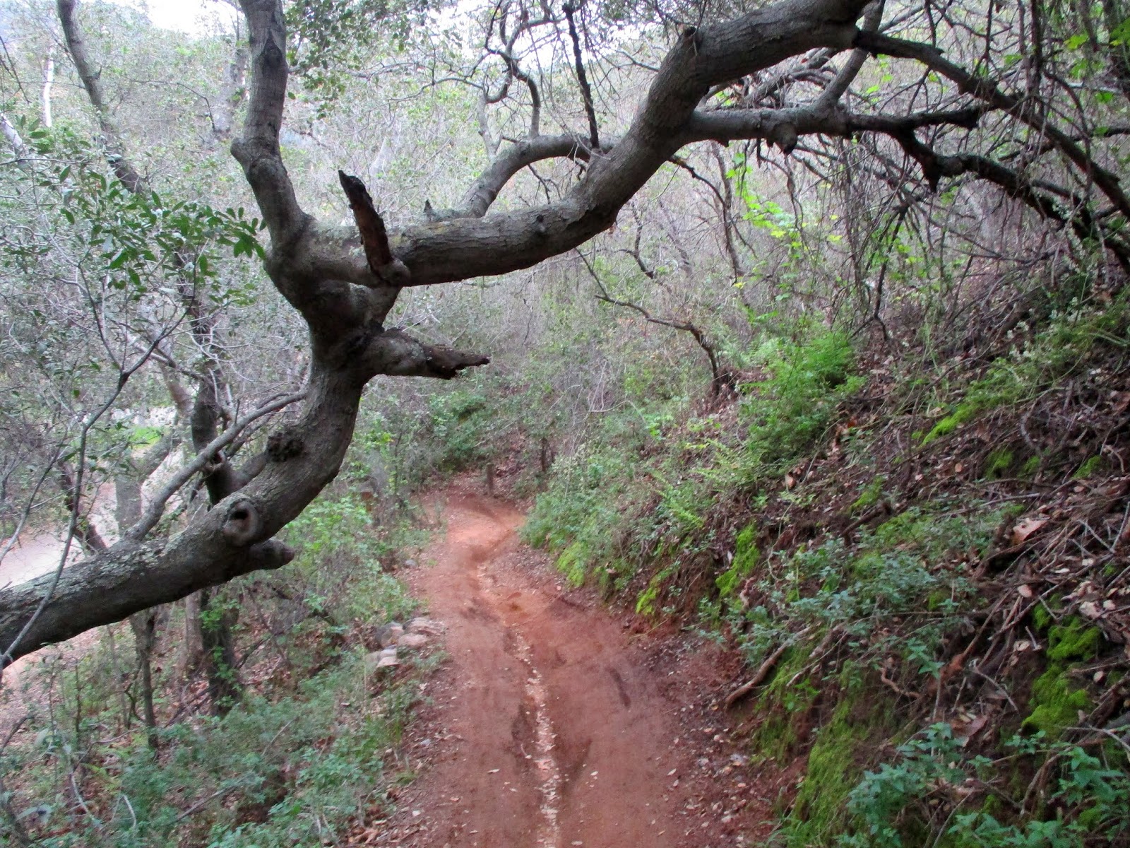
The climb up this truck trail was steep. The sun was hot. But it was all worth it. Surprisingly, not much had changed -- I remembered the same huge boulders, the same fallen trees as I traveled up the rocky road. Maple leaves were just beginning to yellow. A dozen or so four-wheel drivers passed me by, some going up, others down. Not a single person was rude along the way -- everyone either smiled or gave a little wave.

I hiked much of that incline which totaled a little over 4 miles. I also snapped a lot of photos, as if I didn’t already have hundreds of them back at home on hard drives, sd cards, and flash drives (which by the way are scattered all over the place, in plastic baggies, in my book bags, etc).  I also scoured the dirt floor for cat tracks, any animal tracks for that matter. I didn’t see any, though the road was so covered with bike tracks that cat tracks could have easily been obliterated. Still, I felt safe, as the mountain was more active than I’ve ever seen it (except for of course, during races).. There have been times that I’d ventured up Maple Springs and didn’t see a single other soul. It was good to have the company my first time out in over two years.

It was good, so good to be back.

SAMSUNG CAMERA PICTURESSAMSUNG CAMERA PICTURESSAMSUNG CAMERA PICTURESSAMSUNG CAMERA PICTURES

9.21 miles (14.8 km), 1,666’ (508 m) elevation gained9 11 16

9 11 16 a