TALES FROM THE TRAIL (AND SOMETIMES THE ROAD TOO)

Showing posts with label San Juan Trail. Show all posts

Wednesday, August 21, 2019

Point to Point Hike (San Juan Trail)

It has been much too long since I last hit the trails (8/10/19). Eleven days ago to be precise. And then school happened -- my two youngest boys went back to school, and so did I. It all came like a whirlwind and I am off kilter just a bit. I am back to teaching at one of my schools, and at another beginning next week. Gosh, it all came like a fast. I still feel a little out of sorts. Summer vacation was like a race to me, a race to check things off my list. Well, the end of my summer vacation has ended, and I did get some things done. I so feared that I would not. And I was constantly critical of myself over whether I was doing enough. Well, I didn't get everything done. But I certainly did enough. And the most important things, they got a check mark. 

I'm also back to working on Old Goat races (more about that later), so my last hike was to measure San Juan Trail in it's entirety, from Blue Jay campgrounds down to Hot Springs Canyon. You can bet in the middle of the summer, the only way I was going to do this hike was to do it one way -- the downhill way. 

Early that morning (but not terribly early -- 8:30), I met a friend of mine, Jose, and his neighbor, Pedro, at Hot Springs Canyon Road. We drove into the canyon and parked Jose's car. Then the guys got in my truck and we drove to the top of the mountain and parked in Blue Jay campgrounds before setting out on San Juan Trail. The trail was beautiful with views going for miles and miles, as far as the Pacific Ocean. And can you believe it, we were the only people on them. We had some shade, especially in the first third. But after that, the trail is pretty exposed, and the weather was hot. Hot but bearable. There was a tad of uphill, but overall the 12+ mile trip was technical downhill. The fun stuff!


About five miles down, Jose realized that he had left the keys to his car in my truck. Oops. This was indeed a situation being that it was his car down at the bottom of the mountain that we were going to drive back to my truck. I was not so concerned about this. To me, this was just part of the adventure, and I enjoyed the rest of the trip without a thought to the matter. One thing for sure, I wasn't willing to hike five miles uphill back to my truck. I just trusted the guys would figure something out, and if not there was always my husband or son that I could call (if I could get a signal that is). 

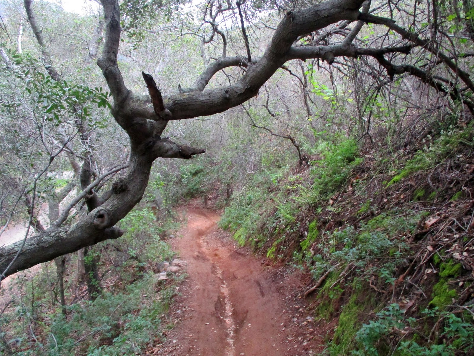
Somewhere in the final switchbacks (look at that lovely pictured below!), Pedro got a cell signal and phoned a friend to meet us at the fire station on Ortega Highway and Hot Springs Canyon Road. We picked up our pace some at that point because we still had quite a ways to travel to the station. I estimate the friend who was driving out to rescue us was about twenty minutes away. We on the other hand were about 2 miles from Jose's car and another mile to the station (which means that our hike was not 12+ miles, it was 13+)

Just about the last tenth of a mile before the bottom of  San Juan Trail, I slipped in the loose dirt on a turn in the trail, and then on my fall, slipped again. I felt like the top half of my body twisted one way, while the bottom half twisted in the other direction. It was quite a jolt. I recall Pedro rushing in to help me up but I just couldn't really focus at the moment. It's like I had to take a moment to process the pain, accept it and then finally get up and get going. Once I did that, I just had to pretend and ignore the pain until I got home and could deal with it. I should point out that I was confident that my injuries were not serious, no broken bones or anything like that. At the worst, I felt I could have torn some tendons in my foot, as the twist and subsequent feeling in my foot felt very similar to the time I tore tendons in my foot on West Horsethief Trail. 

Every hike or run is an adventure, isn't it? Pedro's friend was waiting for us at the station. I drove up the mountain with him, leaving the other two behind because his truck had only two seats. I wish that I remembered his name because he is definitely worth mentioning. What a good friend he was to Pedro. He told me, and I could tell that he was uncomfortable driving up that windy mountain road. I believe he said that it had been 15 years since he had driven up Ortega. I didn't blame him. I used to be scared to death of driving to the top of the mountain (I'm still a tiny bit scared). Anyway, Pedro's friend spoke little English, and I spoke even littlier Spanish, so our communication was challenging. He had no idea what he was in for, and yet he did it with a friendly smile. He got me back safely to my truck. And we both drove back down to the fire station on Ortega Highway and Hot Springs Canyon Road to meet up with the other guys.

It really was a lovely hike. San Juan Trail is challenging, even on the downhill. I was sore for a few days after my fall. When I dress for work now, I make sure that my dress covers my knees so that the scab doesn't show. It is healing up quickly now though. And the scrapes on my arms are barely noticeable. 

All's well that ends well. 


Friday, March 15, 2019

Hot Springs Canyon 3X

I have come to conclude that it’s a good thing that the state and county parks have been closed so much lately “due to wet and muddy conditions.” I was getting so annoyed at OC Parks, but now I am fine. Really, I am fine. All these closed parks have lead me to a wonderful revisit -- a revisit to Hot Springs Canyon. And what an unexpected delight this has been.

Hot Springs Canyon is toward the bottom of the mountain off of Ortega Highway (In the Cleveland National Forest on the Orange County side). The turnoff is by the fire station and the same road that you take to LazyW Ranch. Old Goat’s Chimera (100 mi. race) has an aid station in this canyon. It’s where the runners come off a long 12 mile downhill on San Juan Trail. And then they must turn around and repeat those 12 miles back into the Blue Jay campgrounds. I have frequently travelled San Juan Trail over the past decade. But I almost always stay toward the top of the trail and go off on other junctions like Chiquito Trail and The Viejo Tie. A couple of times I have ventured up San Juan Trail from Hot Springs Canyon. Once, some years back, I ran up the trail from Hot Springs Canyon to Cocktail Rock. One thing for sure, during the summertime, San Juan Trail is a bear. It can get brutally hot, heat stroke kind of hot, if not taken seriously. It’s completely exposed until you get in pretty close to the campgrounds. So, you’ve got about 7 or 8 miles of uphill sun beating down on you if you want to make the trip on San Juan Trail from Hot Springs Canyon into Blue Jay campgrounds.

Oh, how I have digressed. My journey back to Hot Springs Canyon began at the beginning of this month -- March 1, in fact. I got a really late start because I had to pull over and make some unexpected phone calls. It may have been as late as 1 pm before I arrived to Hot Springs Canyon, the location I chose because it was semi-close and all my local trails were closed. I meandered a bit about the creek, which was clear and rushing. Then I gave myself two hours up before I needed to turn back to make sure that I’d get in before dark (we hadn’t changed the clocks yet). The weather was cool and breezy, the skies gray. Little fields of wildflowers were splattered all over the slopes. And moss and ferns were wrapped around boulders and rocks in the shady areas. Wow. This was no summertime San Juan Trail. This was beautifully cool weathered- springtime San Juan Trail. 8.10 miles on this hike; 1,713 elevation gain.


Trip number two into Hot Springs Canyon this month was unplanned. Thursday, March 7, my husband and I had planned a hike in Caspers Park to the San Juan Hot Springs (we have never been). I should have known, because Caspers is part of the county park system, that it was closed due to “wet and muddy” conditions. So, we drove a few miles and turned into Hot Springs Canyon hoping we could find a way to the hot springs from that location. Turned out that the entire perimeter of Caspers is fenced. We did find a spot to squeeze through, but being that the place was so heavily fenced and plastered with no trespassing signs, we decided to squeeze back through the barbed wire fence and did a short creek hike instead. We crossed the creek several times before reaching LazyW Ranch. We took in every cabin (as close as possible). Everything was clean and green. Some of the cabins had the creek flowing just past their front doors. What a lovely spring canyon. 4.03 miles on this hike, plus a little more walking around at the Tree of Life Nursery down the road a bit. (Wonderful nursery with all California native plants).


The very next day, Friday March 8, I got back out to Hot Springs Canyon. I had five hours. I really needed to get back to the car by 4pm so that I could bring my son to an appointment. (Just in case though, I had left directions on the kitchen counter so that my husband could bring him if I didn’t get back in time.) My goal was Cocktail Rock, which I estimated was around 6 miles away (uphill).

Well! The day was absolutely lovely with big puffy clouds and blue skies. Spring flowers were bursting all over the place. I could see down to the Pacific Ocean and for miles into the Cleveland National Forest. It really was amazing. But my time was not good. Cocktail Rock was slightly further than I expected. The weather was super cold at the rock, and the wind began to pick up. It took me slightly more than 3 hours to arrive there, and I wasn’t going to turn around and go straight back. I did recorded some video, took in the scenery. By this time though, I basically had 1 hour and 45 minutes to make the trip back, which I could conceivably do if I ran it. Funny thing was, my phone rang when I was hanging out at Cocktail Rock (did not expect any service there!). Learning that I had cell service, I gave my husband a call to let him know that he would have to take our son if I didn't make it in time. I had fun running back (as it was basically all down hill). But the trail got too technical in some parts, and being that I’m not really practiced at running this level anymore, I slowed it down during those portions.  I did not make the return trip in 1 hour 45 minutes. But I was close. It took me just a little over two hours. Total distance: 13.11 miles, 2,546’ of elevation gain. And that is why Hot Springs Canyon 3 times!


Saturday, January 26, 2019

Chiquito/Chiquita Falls are Falling


The last time I hiked out to Chiquito Falls I said that the next time I visited they’d be falling. AND THEY WERE. Monday (Martin Luther King, Jr. Holiday) I was off from work, so I drove up Ortega Highway and into Blue Jay Campgrounds. Due to the government shutdown, the campgrounds (and all the bathrooms) were locked (because you know, the peasants might go out and play on the king’s land).

I parked outside of the campgrounds on Long Canyon Road and trekked through the grounds to see at least 3 people camping. They parked outside too and hiked in their gear. I mean, who was going to enforce the closing if the government was closed? Nobody, that’s who, and good for the campers too who made the trip all the way up the mountain to find it closed. I do not believe that the actual trails were closed (that would be absolutely unenforceable), but all the campgrounds were for sure.

Despite the government locking us out from the people’s land, the trails were gorgeous on Monday, and they were empty too (until I reached the falls). I took Old San Juan Trail to San Juan Trail. And then, instead of getting right onto Chiquita Trail like I usually do, I opted for The Viejo Tie, which takes a bit longer. I was missing the tie, it had been years. And The Viejo Tie did not disappoint. It was just how I remembered – single track winding between giant boulders arranged on sandy desert-like dirt and then shady, lush areas with moss and shrooms. 


It got even better – Chiquita Trail was lush and green from all of our rains, and the creek was full. The trail was like an enchanted forest with green moss covering the rocks, and a lace like canopy meeting above. At one point, I noticed an animal running toward me on Chiquita, and as usual, it took a couple of seconds before I could determine the animal. It’s a strange thing that when I see an animal coming toward me my sight and thought are not synced. It takes a few seconds for my brain to register what type of animal I’m looking at. My brain registers the picture, but naming it comes a few seconds later. On Monday, it was a gorgeous gray fox. At first, after registering the longish snout and the big pointy ears, I thought coyote. But then my brain settled down and I registered its short legs and the creature’s closeness to the ground. Definitely a fox, and unfortunately, by the time I got my camera out, the fox realized that he was running straight toward a human, turned around and darted off the other way. I do not believe that I have ever caught a picture of a fox. I have perhaps seen a  half dozen on the trails, some in California, others in Texas. 


The falls were falling, and they were crowded with people who had hiked up from The Candy Store on Ortega Highway. There must have been a half dozen hikers laughing and having a good old time as they feasted on fruit at the top of the falls. There another guy playing a ukulele in the high grass right next to the pool, and a male/female couple sitting on the rocks a little further down. After about 15 minutes though, everyone left, and except for the water, it was silent. I had the falls completely to myself. (I posted a 50 second video of the falls here)


I loved this hike. It totaled 9.82 miles with 1,654‘ elevation gain (though that gain was really over about half of that, 1,654' feet in about 4 or 5 miles). I also ran a bit because I was falling behind on time. I took San Juan Trail all the way to the end (or beginning) which I haven’t done in years. It was delightful. It felt good to have dirt beneath my feet. And I didn’t even feel clumsy along that pretty technical trail.


Sunday, November 4, 2018

Clearing Chiquita

We are still in prep mode for Chimera (11/17-11/18), hiking out to the trails every weekend to clear fallen trees and stash water. It’s been fun, and at the same time. I’d like to clarify something before continuing though. Is the trail off of San Juan and San Juan Loop in The Ortegas called Chiquito or Chiquita. Well, for years I called it Chiquito Trail because that’s what all the official maps read. But everyone, and I mean everyone, calls it Chiquita Trail. I felt a little foolish being the only person I know who calls it Chiquito Trail. Well, it turns out, and this is pretty funny, that the sign at the San Juan Junction reads: Chiquita Trail. But the sign at The Viejo Tie junction reads Chiquito Trail, and the sign at the San Juan Loop junction, reads Chiquito Trail also. That’s pretty dang hilarious. So, I decided I’m going to call it what everyone else calls it, Chiquita Trail, even though 2 out of 3 of the signs read Chiquito Trail.
Anyway, I ended October (10/27/18) with another trip to the Chimera trails. We stashed water, and did some trail clearing. It’s looking pretty good now, and we have about 72 gallons of water hidden. That is about 70 gallons short of our goal. It’s tough getting volunteers to hike that those technical trails weighed down with water. But thankfully, we have a few hearty souls every weekend. It’s a fun, hard workout, and also thankfully, we have nice breezes being that we are fully into autumn. Gotta love, love, love that autumn.
And so does this baby tarantula:IMG_4817IMG_4820IMG_4835IMG_4823Taking selfies while the boys work Winking smile:IMG_4843IMG_4847
Total miles: 7
Elevation gain: 1,151

Thursday, February 26, 2015

Beauty Vs. Brawn

Sunday, we got a good downpour here in the land that seldom sees rain.  I know that we need the rain, but rain spoils things for me, especially since Mondays are one of the few days that I can get out and run.  As expected, all my local tails were CLOSED “due to wet and muddy conditions.”

Well, I had me a full tank of gas, so I thought, “Hell with it,” and headed up Ortega Highway in my beloved truck.  I know that I would have been better off staying home and putting in miles right out my front door.  I would after all, have time to get in some good mileage if I had chosen that route.  But what I wanted was beauty, not brawn. 

I pulled into Blue Jay campground an hour later, and felt calm and joyful being back to this lovely location.  The ground was still muddy, a few campfires smoldered beneath overly cloudy, cold skies.  Gosh, it had to be 50 degrees F!  (I’m so sorry – I know that isn’t cold for the rest of the world, but it is cold here).  Branches were strewn about; no trees were down, though a few widow makers hung precariously from branches above.  I felt so at home that I could have pitched a tent and stayed a week.  

I cannot adequately relay just how happy and peaceful I felt.

0223151123-00

Since hubby had indicated that he would pick up the boys from school, I took off down San Juan Trail feeling like I had all the time in the world.  I did not see another soul on the trails as I made my way toward the San Juan / Old San Juan Trail junction.  But I was not alone.  The forest was alive with sound – critters scrambling through the brush, birds singing anonymously among the trees.  Listening to this music, I had no desire for man-made music, and kept my ear buds hanging over my shoulders. 

I spotted my destination, Sugarloaf Peak, a mile out.  It took some trial and error to find the path that leads to the entrance at the top.  Then it was climbing time, scooting over boulders, grabbing onto branches.  My legs were scuffed with scratches.  Oh the glory. Winking smile 

0223151235-01

0223151244-00I summited Sugarloaf Peak and took a seat on a large flat boulder. I could see Los Pinos Trail climbing up the mountain on my right.  I could see as far as the Pacific Ocean, with ridgeline overlapping more ridgelines reaching out to my left.  I had my beauty.  And it took some brawn to get it.  (The best of both worlds).

The wind picked up; the temperature dropped.  And I simply sat there on that rock and took it all in – the sights, the sounds, the chilling wind.  It was a little spooky, like the wind might swoop me off my rock.  I dug around in my pack and replaced my cap with a wool beanie, and I was good for the cold.  Then I sat some more.

0223151242-00

Eventually, I felt that I ought to get going – not that I wanted to go (I could have stayed all day).  I just needed to get back to reality because I do have a wonderful family back at home (young sons that I desire to see, since I miss out on so much with this crazy work schedule).  And I also had a meeting with my boss later in the afternoon.  

I finally glanced at my garmin when my feet hit Old San Juan Trail.  It read 1:10.  Flabbergasted, I thought to myself, “This must be time elapsed – it CANNOT be 1PM!”  But, alas it was after 1PM (time elapsed was much greater).  One might think that since it was so dang late, that I would have picked up my step a bit.  But I did not.  Instead, I lackadaisically ran back (because that is the way roll) toward my truck. 

0223151247-000223151247-01

At the Old San Juan Trail / San Juan Trail junction, I decided to take a so-called short-cut by going straight up Old San Juan instead of meandering San Juan.  (Okay, we have two trails out here called “San Juan Trail”, not to mention an additional “San Juan Loop.”  We have an older, less travelled trail, the original San Juan Trail, that we call “Old San Juan Trail.”  And we have a new San Juan Trail that we call “San Juan Trail” or “New San Juan Trail”.  Just thought I’d straighten that out).  Now, speaking of so-called short-cuts, I know darn well that “short-cut” never really means that the trip is shorter in time.  In fact, short-cuts are usually much more difficult.  And that it was.  But it was a lovely struggle getting back to the truck.  All that beauty was well worth the brawn. 

2 23 15

Saturday, April 12, 2014

Not Ready

I overslept this morning and changed my mountain running plans to coastal hills running plans.  Then I changed my plans back to mountain running.  My feet didn’t hit dirt until after 9AM.  That’s okay though.  I felt rested and strong as I started the first leg (the uphill leg) of my version of The Candy Store loop.  There many variations of this “loop” out there.  The main parts of the run however, are always the same:  Around 20 miles long, it starts or ends in the lot across the highway from The Candy Store, and goes to Blue Jay Campground, with the main trail being a long technical, rocky Chiquito Trail (which passes by Chiquito Falls, dry now for a good long while).

Fortunately, I experienced a cool breeze practically all day.  Also in the fortunate category:  I am still immune to poison oak, as the shady portions of today’s run were covered with the plant.  However, unfortunately, I was NOT ready for this difficult run.  I felt so fatigued, I experienced light-headedness and needed to force down additional calories.  I also poked my leg by running into cactus, resulting in a trickle of blood.  Then I fell flat on my butt running down a steep Old San Juan Trail.  Running the uphills on the return “downhill” portion really got my goat.  At one point, I turned a bend to find another uphill on my “downhill” route and hollered out a profanity.  

On the slightly humorous, Lauren-peculiar side, a set of hikers stopped me with three miles remaining for my run and asked, “How much longer?”  At that point, my brain could hardly form a thought.  But I did manage to sound like a ditzy broad when I replied “How much longer to where?”  (It always cracks me up when people ask me how much longer, as if I know where they are going).  The group of three looked at me questioningly until I re-phrased my question to “Where are you going?”  One of the guys answered, “Chiquito.”  Still barely able to form a coherent thought, I answered, “You’re on Chiquito.” 

Turns out they were  hiking to Chiquito Falls (which I should have guessed – duh!).  And though I figured out “how much longer” after we parted ways, I was only able to tell them that the falls are five miles from the parking lot.  I forgot to mention that the falls are dry.  Smile

Despite not being ready for this run, I did finish it.  I finished it without collapsing and without calling 911.  I didn’t even run out of fluids.  Hooray for the fresh water in Blue Jay!  Who cares that my lower left calf aches (grocery store accident), and the plantar fasciitis in my right foot is having a painful flare-up. 

Going Up . . .

Much Appreciated Shade:

So, so, so happy to hear the cars from the road way down there – I was almost, almost finished:Running Candy Store Loop 4-12-2014, Elevation

Route:  San Juan Loop, Chiquito, Viejo Tie, San Juan Trail, Long Canyon Road in Blue Jay, Old San Juan, Chiquito, San Juan Loop.